Dominarian Cartography

Lots of Cool Things
When I first came to work at Wizards of the Coast in 2011, there were lots of cool things here. Sleeves that looked like Limited Edition (Beta) Black Lotuses, a huge Shivan Dragon statue named Mitzi, and cabinets full of (nearly) every Magic card ever printed. But the coolest object in the building was the globe sitting on Brady Dommermuth's desk. It had been painted white, and all of the continents and islands of Dominaria had been meticulously drawn on it in black ink. The tectonic plates' boundaries and their movements were indicated with red lines and arrows, and little paper labels identified some of the continents. Someone had clearly put a great deal of care and attention into making the globe, and as a scholar-squirrel, I appreciated what a unique item I was looking at.
It turned out that Pete Venters had created the globe back in the '90s. I had an opportunity to interview Pete a few weeks ago about his involvement in Dominaria's worldbuilding.
The Pete Venters Interview
Ethan Fleischer: Many of our readers are no doubt familiar with your Magic card illustrations, as your name appears on more Magic cards than nearly anyone else's. What folks may be less familiar with was your role as a Wizards of the Coast employee. Can you please describe the work you did and the hats you wore while in Renton?
Pete Venters: I was a member of the Continuity team from July 1995 to May 1998. I worked on everything from Alliances through Urza's Saga. When Tempest was being developed, the Continuity team became part of the new Magic Creative team and I gained the title "continuity manager," but my role was pretty much the same.
During those three years, my job had a variety of duties:
- Overseeing the development of card titles and flavor text. This involved collating submissions from chosen in-house writers and running the endless meetings between myself, two editors, and a member of R&D to pick the best pieces. These were long sessions, and I think my record was 36 hours of meetings in a 40-ish-hour week.
- Writing the art descriptions for every single card from Alliances through Urza's Saga except for the Un- sets (which didn't need Continuity input) and Portal: Three Kingdoms (whose flavor was developed out of house). It was a little bit of a bottleneck to have one person handle all the art descriptions, but it was actually easier for me to track the use of concepts, scenes, and compositions myself than be cross-referencing the input from several sources. My visual memory is one of my strengths.
- Writing new story content, from storylines and worldbuilding (such as the creation of Jamuraa) to Duelist articles and helping with marketing materials.
- Assisting with the creation of style guides for the Magic Creative team, with an eye to internal consistency and how new worlds and characters fit into the larger picture.
- Development of Dominaria and the other planes and the collation and refinement of information from previous Magic sets. Props should also go to my teammate Scott Hungerford, who was in charge of much of this. He also came up with the brilliant name "Weatherlight."
- Reviewing card art sketches and finals for story issues and noting any card titles that might need to change to better fit the artwork.
- Communicating with our licensees and outsourced talent regarding facets of the Magic IP.
I think I'm exhausted just writing that.
That does indeed sound like you had a ridiculous number of things on your plate! The fact that you wrote all the art descriptions yourself boggles my mind. We have a whole team for that now!
How did your work as continuity manager impact the novels and other material that was released at the time?
A great deal. Myself and Scott worked very closely with Jeff Grubb to develop the Brothers' War book and help him with the broad strokes of the other parts of the trilogy. I really pushed for The Brothers' War to be a trilogy, but the book department was being very cautious with their new line and it never came to pass.
In the closing months of my three years at Wizards, we had a week-long meeting with all the writers working on the upcoming novelizations of the Weatherlight Saga. I wrote a document for those meetings entitled "What We Know, What We Don't, and What We Should" that applied those three points to every major character in the saga. This helped the writers understand what was set in stone and where the possibilities for development were. That document was a big hit.
Ironically one of the projects I had the least involvement with was the Rath art book. Much of what was in there was pulled from the style guides, so unless they were careening into new territory there wasn't much for me to add. I think the foreword was my biggest input.
It was really clear to me, working with the old maps and the novels from that time, that the authors had a lot of good reference material and/or guidance to maintain the setting's continuity.
In our modern worldbuilding process, we tend only to create world details that we believe will appear on cards. What were the requirements that impacted Dominaria's worldbuilding, and what are some interesting results of those requirements?
Well, for every set's style guide we, too, kept to details we felt likely to appear in card form. That's just a necessity of limited time and resources.
Dominaria was different, though, because a vast amount of story content had already appeared on cards and in books before the Continuity team existed. Wizards wanted to expand the Magic: The Gathering setting into other media (books, comics, movies, other games) and needed the foundations of the IP developed and unified. Scott interviewed all the creators of the sets that predated Alliances, and those interviews helped us refine the earliest sets' story elements into a database. From there we did a massive "join the dots," figuring out places and times for many characters (Legends was particularly difficult, as it's meant to be many, many different stories). We tried our damnedest to never contradict anything that had been printed, but some details had to be changed to keep things manageable, and others could simply be hand-waved as opinion and hearsay.
At first there was some resistance among players to more defined stories. People missed the sense of sprawl and apparent depth of those early sets. If you'd been able to peek behind the curtain, you would have found a lot more chaos than you bargained for.
It's amusing to me how much this reflects my own experience with Dominarian worldbuilding. It seems to be a consistent problem that the folks working on the plane have to find a way to tie together a sprawling mess into a coherent setting.
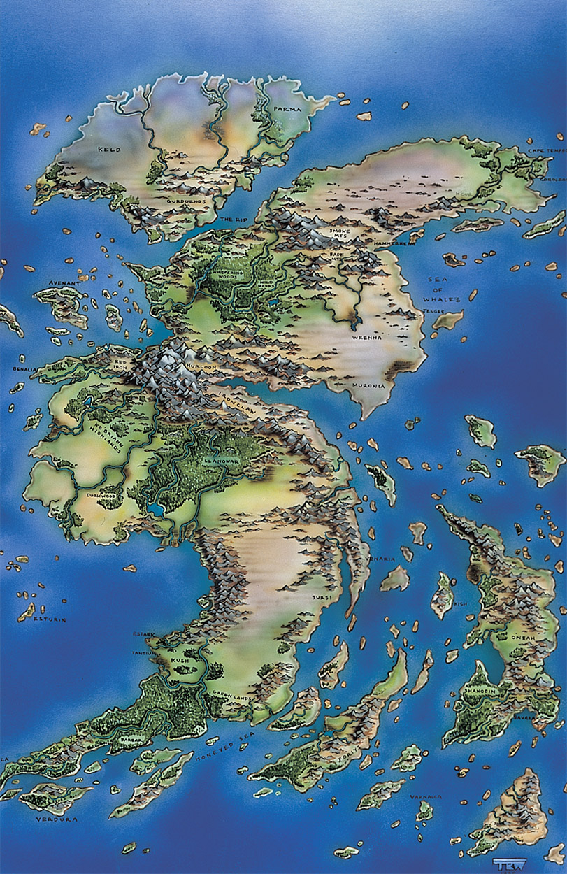
How did you go about making the early Dominarian maps, such as the Domains map and the Jamuraa map you made with Tom Wanerstrand, or the Terisiare map that appeared in the Urza's Saga calendar? (I assume that was your work.)
I initially drew each landmass in Adobe Photoshop. This allowed me to do simple iterations with the shapes before starting on more complex final renders.
For Jamuraa, it was about locating the nations of Femeref, Zhalfir, and Suq'Ata and the geography around them. Because the underlying story of Mirage is one of war, it was necessary to do this to get a feel for where the battles might take place and how the colors of Magic would be drawn into the conflict.
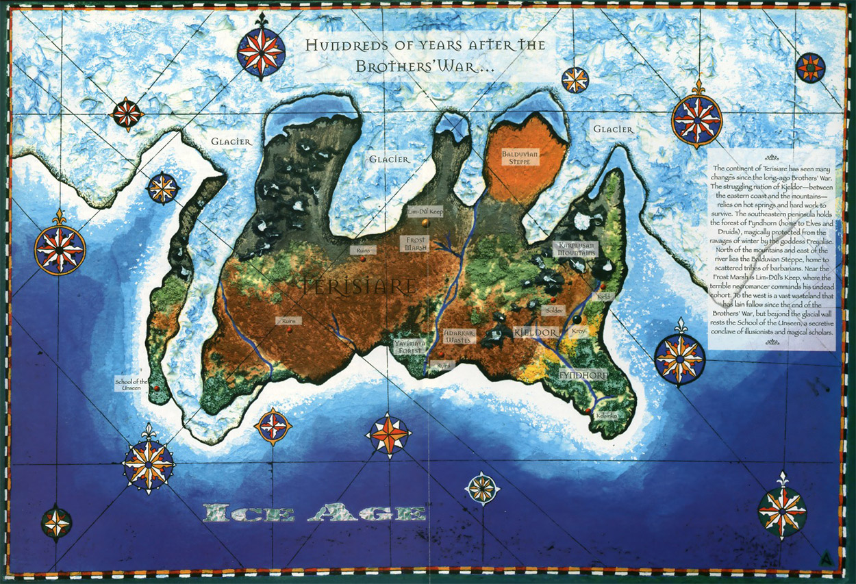
With Terisiare, I wanted to move away from the "crushed spud" look of the original Terisiare map that appeared in an early issue of Duelist. That simplistic shape was feasible for a small island, but Terisiare is a few thousand miles across. Thankfully the fact that the map looked like the product of an ancient explorer gave us an out, and I could develop a more detailed version.
The Terisiare map actually existed as four versions, each for a different time period (thank god for Photoshop layers!): The Antiquities/Brothers' War version, the Ice Age version with its glaciers, the Alliances version with its rapid flooding due to the magical storms that ended the ice age, and finally the modern-day map that shows Terisiare broken into a number of smaller landmasses. The first of these iterations was given to Tom Wanerstrand to create a hand-drawn version for the calendar. Sadly, I believe the layered file was actually lost during one of my computer crashes.
The Domains map was especially unusual because it not only had to define the positions of several nations and races at the core of Limited Edition (Alpha) Magic, it also had to meet the needs of the team that was developing the Magic role playing game. Yes, there was an RPG in development, but it fell victim to the widespread cuts the company made to its RPG lines as 1995 came to a close. But in those short six months we laid out the places that would become a likely part of a player character's life as they leveled.
To use purely Dungeons & Dragons terms, the Domains was the starter area for levels 1–10. Jamuraa and Shiv, home to harsh environments and tons of dragons, were for levels 11–20. But epic adventures of levels 20–30 were located in Terisiare and Sarpadia. Terisiare, the home of the Brothers' War, is filled with powerful artifacts, but they're buried and often submerged—that's also another reason so much of Terisiare was sunk beneath the waves for modern day. Whereas, Sarpadia . . . well, I've always felt the thrulls would win and now rule that continent absolutely. Any player characters unfortunate enough to land there were going to find themselves on the sharp end of a fantasy/horror story crossbreed.
While all this was being developed, I'd managed to reintroduce the Phyrexians as the Soldevi Steam Beasts in Alliances, but where Phyrexians would sit in this RPG power hierarchy was never discussed.
So really, transmedia storytelling is nothing new to Magic. Many of the regions are the way they are to support already existing stories.
The fact that each region is separated from the others by absolutely enormous oceans is really a game design solution to keep adventuring parties from accidently wandering into areas with dungeons that are too difficult for them to handle!
So, what made you decide to make a globe of Dominaria? How did you go about it?
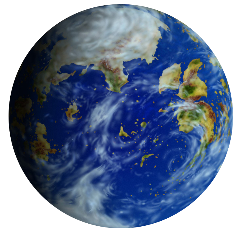
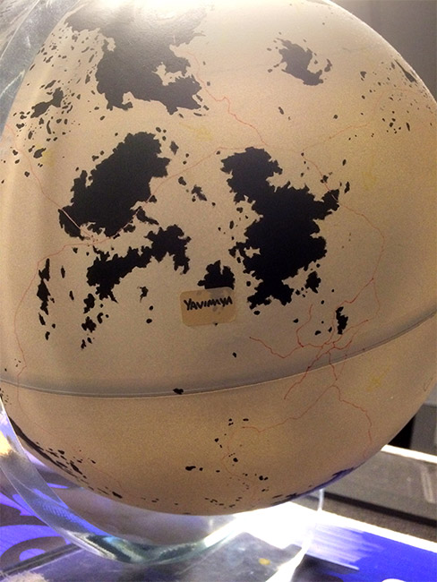
Before discovering Magic, I played and ran a lot of RPGs. I was always a fan of worldbuilding, but I was often frustrated by world maps that really didn't show everything. I felt to really know Dominaria and to get an appreciation for how characters might traverse its enormous oceans, I needed to see it in 3D.
I bought a regular globe at a thrift store and stripped the vinyl coating from it to reveal a bare plastic sphere. I then covered the globe with several coats of white car spray paint. After that I printed out my completed maps to very specific sizes, meticulously traced the outlines and transferred them to the globe, then inked the landmasses in black. After I had placed the ones I had already developed in Photoshop, I began adding the rest of the landmasses, always with an eye to how their nations might interact due to proximity. There's a reason that the portion of Jamuraa that has the most Viashino is relatively close to Shiv.
Even the boundaries of tectonic plates were added (in a faint yellow) as this helped place mountain ranges, which then dictated rain shadows, deserts, jungles, etc. It also shows a certain Homarid/Viscerid-infested trench stretching from Sarpadia to the shattered remnants of Argoth.
The globe was left as black-on-white so it could be photographed and used as a Photoshop mask for creating images of the planet. I got to do one of these pieces as an accompaniment to one of my Duelist articles. I also hoped to one day be able to scan it for creating cool maps, but the technology just wasn't there at a reasonable price.
The globe was a labor of love that I had to keep putting aside for card set deadlines. But I do remember one set had to have another couple of weeks of development due to the discovery of a late-stage issue, so suddenly my schedule had some space and I finished the globe before the card naming process kicked into gear.
As the one who eventually did the work to flatten the globe out into a two-dimensional map, I appreciate your foresight in painting it in high-contrast black and white. It certainly made my job a lot easier! And thanks for taking the time to do this interview.
For more details on Pete's worldbuilding process, check out the interview he did with Matt Cavotta—jeeze, was it eleven years ago?!
Terisiare
Now that you know where the globe came from, I'd like to explain how we went from the black-and-white globe sitting on a desk in R&D to the beautifully rendered map you can all enjoy today.
Five or so years after I started working in Magic R&D, I had managed to not only get onto the Dominaria Vision Design team, but also the Dominaria world guide writing team! For every block, we make a book that acts as a unifying creative vision for the setting. We send this out to the artists and writers who will illustrate the cards, write names and flavor text, and so on. I had made something of a name for myself as an aficionado of old Magic lore, a predilection that was certainly called for in this instance. Normally, I confine myself to designing the gameplay of Magic sets, but I enjoy Magic's worldbuilding a great deal, and was happy to get involved in it for Dominaria.
Kelly Digges was in charge of the writers' portion of the world guide, and assigned various regions and factions to the different members of the team. Each team member would do a deep research dive to learn everything they could about their region or faction, discuss things with the group, then write their section of the world guide. I was assigned the island of Yavimaya, and incidentally the archipelago of Terisiare to which it belonged.
Terisiare was particularly interesting because it is perhaps the most storied region of Dominaria. It was originally a continent, one that shattered into islands as a result of the destruction wrought by wars and climatic changes. It was the setting of many of the early Magic sets: Antiquities, The Dark, Ice Age, and Alliances. It played important roles in the stories of the Urza's Saga, Invasion, and Time Spiral blocks.
Of course I hit the books, but I also poked around the corners of the internet where Vorthoses gather. I found lots of great leads on sources I should look into, as well as scans of maps from magazines and calendars. Among them were three different maps of Terisiare.
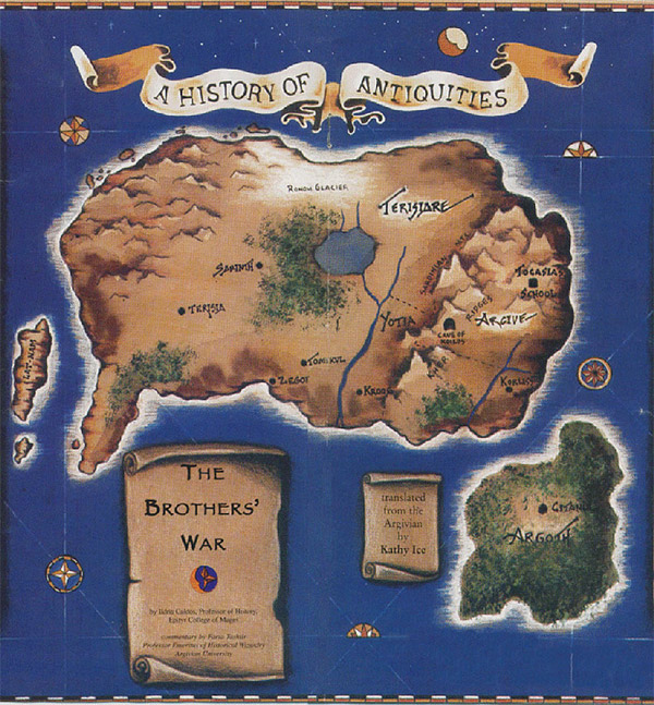
This is the first Magic: The Gathering map, published in the Duelist Supplement in 1994. It depicts the continent of Terisiare and the islands of Lat-Nam and Argoth offshore. This is the map that Pete Venters referred to as "the potato map" for its resemblance to that starchy tuber.
Here's a map from centuries later, during the ice age, from Duelist #5. As you can see, the geographical features may have changed, but the Papyrus font lives on.
This is where things start to get interesting. This map is from the 1999 Urza's Saga calendar, and represents the same time period seen in the "potato map." As you can see, the topology of the continent is much more detailed and realistic. I compared this map to the globe, and it was a perfect match . . . sort of.
Part of the backstory related to the Alliances set is that, due to overmining, the effects of the Golgothian Sylex's detonation, glacial action, and Viscerid engineering, huge areas of Terisiare were flooded out, turning the continent into an archipelago of four great islands and many smaller ones. The outer coastlines on the globe matched the coastlines on the map exactly. I had a sudden inspiration. I snapped a picture of Terisiare on the globe.
I put both pictures into Photoshop on different layers. I knocked out the black areas of the globe picture and adjusted things to line them up properly. Now I could see which parts of the continent were underwater in modern times, and which parts were still above water!
I knew from my research that certain locations were on the same sites as locations from previous time periods. Soldev was near Koilos, which itself was close by the Thran city of Halcyon in ancient times. Tresserhorn was located on the site of the Monastery of Gix. The School of the Unseen was on Lat-Nam. I roughly lined up the Ice Age map with the Brothers' War map.
It's pretty common for cities to be built on top of older cities. The ancient city of Troy had nine layers. Seattle is built atop an older incarnation of itself. People generally build cities in particular locations for good reasons, and those reasons are frequently still valid even millennia later. I thought it would be cool if some modern-day cities were built atop the ruins of ancient sites.
I went really deep with the research at this point, starting with the novel Planeswalker by Lynn Abbey. I followed Xantcha through her adventures, writing down which direction she headed from where. It became more and more possible that she and Urza were living on the big island that comprised northwestern Terisiare. The smoking gun was eventually revealed when she mentioned the wasteland of Kovria! This matched the name of a desert where Terisia City used to stand, mentioned back in the Duelist Supplement! This allowed me to label the Ohran Mountains, Efuan Pincar, and other locations, and more importantly gave me the name of the island itself: Gulmany.
I performed a similar exercise with Song of Time by Teri McLaren, which is the only source detailing the island of Almaaz, and Invasion by J. Robert King, which gives detailed descriptions of Yavimaya's geography. Lat-Nam and New Argive required more synthesis on my part, tracking down details from a variety of sources. I sprinkled some throwaway place names a bit arbitrarily, and I had an ugly but serviceable map!
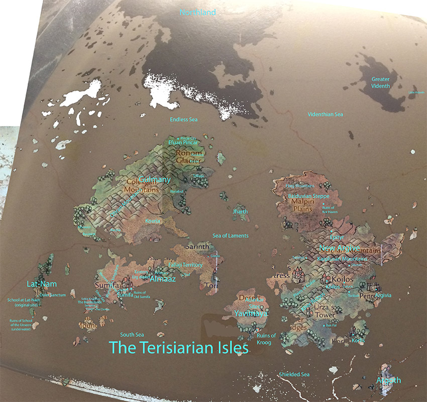
Serviceable, but not that serviceable. The map was pretty hard to read. I quickly made a nicer version by converting a photograph of the globe into a vector image and digitally painting in the mountains, deserts, etc. I marked the modern-day locations I'd discovered in the course of my research. I also made a few changes to bring the map into the "present day" of Magic's storyline, most notably by adding the magnigoth mangals and the Yavimayan colonies on Almaaz and New Argive.
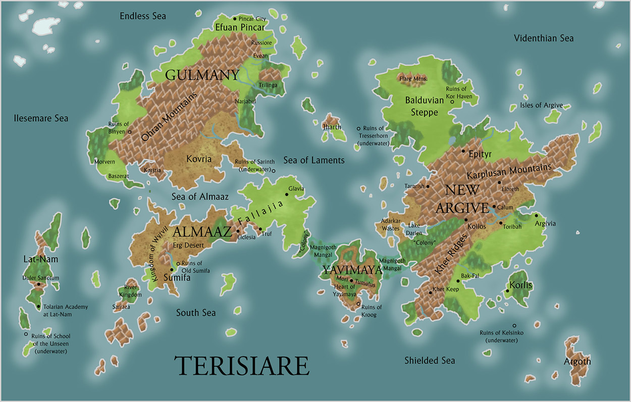
Figuring out where all of the different Terisiarian geographical features were in different time periods really helped me to reconstruct the history of the continent/archipelago. The material I wrote for the world guide approached this history from Yavimaya's perspective, as Yavimaya was one of the major regions we wanted to cover for the guide.
Projection
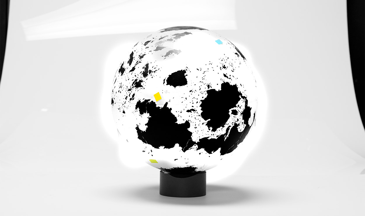
I was really excited about the idea of bringing a map of the entire plane of Dominaria to our fans, and Kelly and Mark Winters agreed that we should. As time went on, two things became clear. One was that there was nobody driving the process of creating the map. The other was that I enjoyed working on this sort of thing. With Kelly's permission, I took it upon myself to make a projection of the three-dimensional globe onto a two-dimensional image.
I should mention at this point that I have no cartographical training. I was figuring it out as I went along, and I'm sure I made a few mistakes along the way. I tried to treat the work of Dominaria's many previous contributors with respect while making this new map.
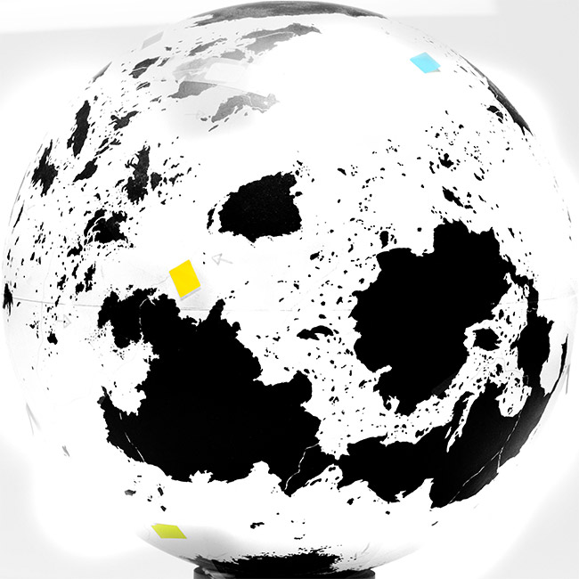
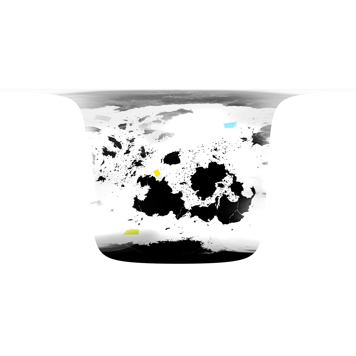
My starting point was Pete Venters's globe. This was the foundation of the map work. Nick Bartoletti, one of the 3D artists working at Wizards, photographed the globe from dozens of angles under good lighting conditions. I figured I could use the photos that were shot from directly over the equator, as well as the north and south polar shots, to generate the map.
Here's an example of one of the photos:
For each photo, I cropped out the extraneous parts of the image, leaving a square image with the globe touching the middle of each edge. I also needed to rotate it a degree or two clockwise or counterclockwise. Though the photos were close to perfectly oriented, I knew that every degree would count for a project like this. The equator needed to be exactly level.
While the equator was level, it wasn't straight. In each picture, the globe was tipped slightly toward or away from the camera. I needed to determine the latitude that the camera was directly over and compensate in the next step. This is where I had to reconstruct my long-neglected high school trigonometry skills. Aspiring game designers take note: I have needed to use trig about once every six years as a game designer. Math is well worth learning!
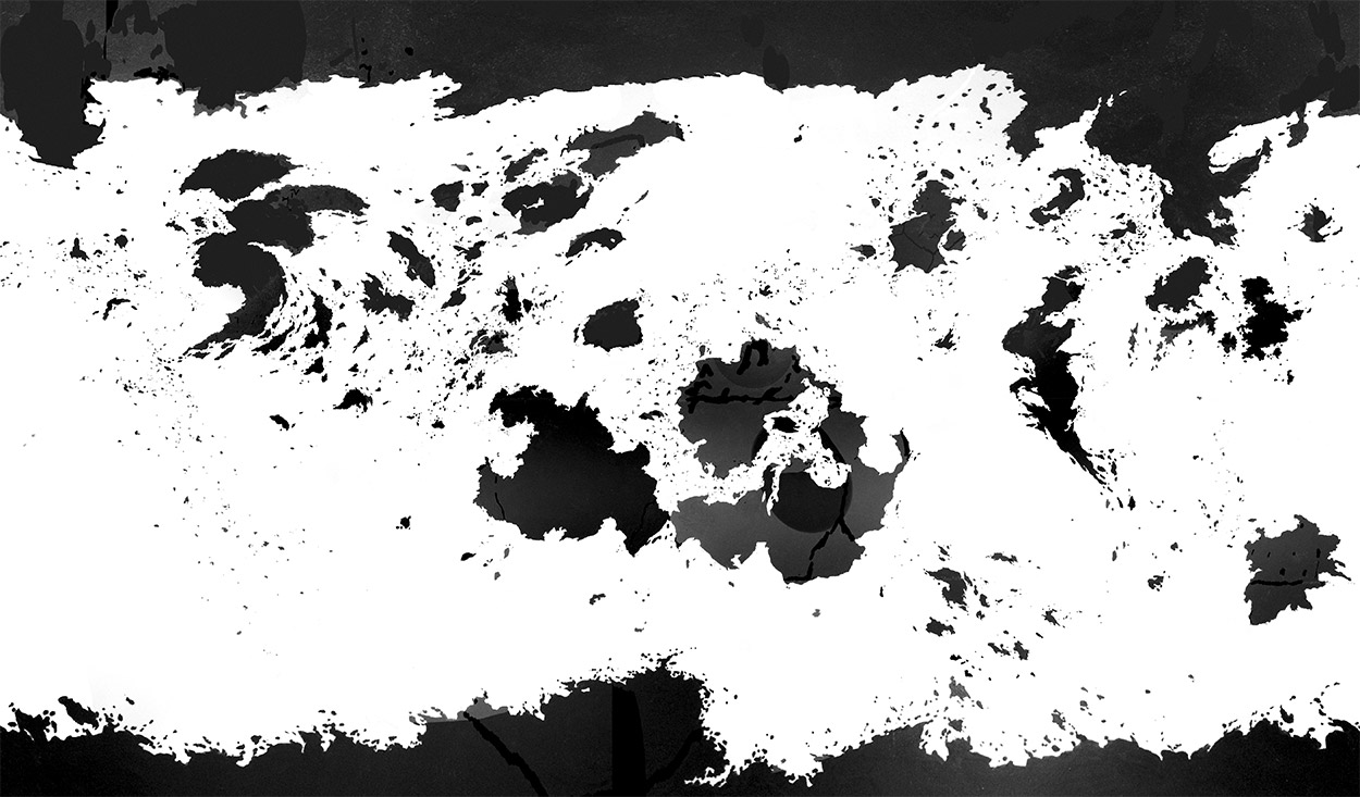
I got on the NASA website and downloaded some great software that could unwrap the photos (assuming I provided accurate latitude numbers). I applied the software to each of my photos, giving me a series of images similar to the one below.
Stitching the images together into one big image was a relatively simple task for an experienced image manipulator such as myself. I now had a crude, messy map of Dominaria!

This is known as a plate carrée projection. This projection is most accurate at the equator. The closer to the poles a geographical feature is, the more squashed it becomes north-to-south and the more stretched it becomes east-to-west.
I had clearly made a mistake somewhere in my process. The image should have been exactly twice as wide as it was tall, but it was wider than that. I tried simply adjusting the aspect ratio, but that immediately looked wrong to me. Maybe the error had something to do with the distance the camera had been from the globe when the photos were taken? Did my process assume an infinite focal length or something? I couldn't figure out where I had gone wrong, so I simply added more black areas to the top and bottom of the image and moved ahead on the project.
Though the image was pretty high-contrast, there were still enough dark areas in the oceans, light areas on the land, and various artifacts (stickers, labels, lines representing the equator, tropics, and tectonic plate boundaries) that I decided to clean up the image before moving on to the next step.
The cleanup was quite tedious. It was a very manual process of painting black over dark gray areas and painting white over light gray areas. It was a huge image, so it took quite a few hours to clean it all up.
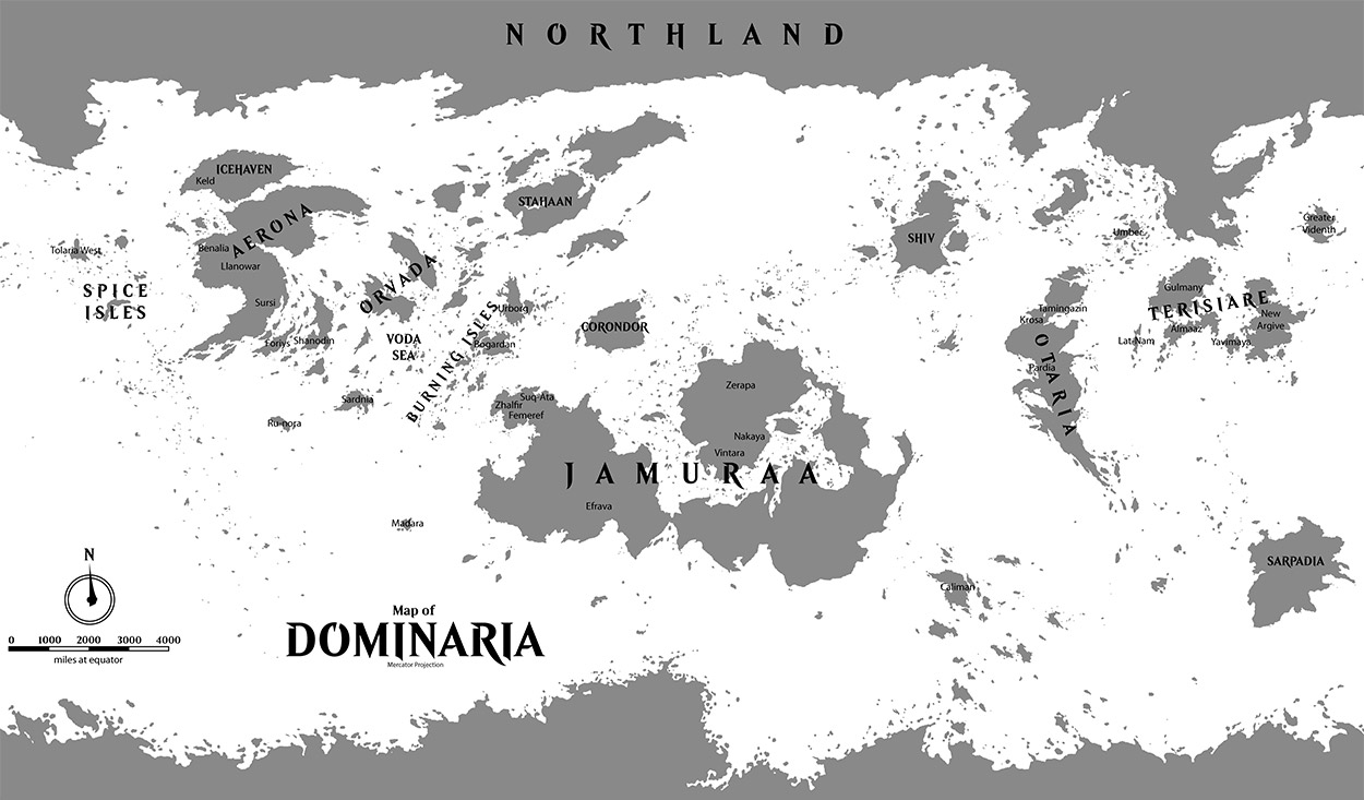
I wanted to change the projection to something a little more accurate and nicer looking. I didn't want it to look too modern, as I wanted it to be something that the people of Dominaria could have made without the aid of computers or advanced algorithms. I settled on the classic Mercator projection, which maintains the shapes of landmasses pretty well (though objects near the poles are overly large) and fills a rectangular space. My NASA software converted the map easily.
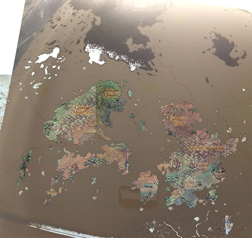
My image now had high enough contrast and was clean enough to convert to a vector format, which would make it easy to scale and use for various purposes. I put a few location tags on the map to indicate where various continents and nations were.
Filling In the Blanks
I had been working at a rather leisurely pace, putting in time on the map after work and on the weekends mostly. Mark Winters dropped a bomb in my lap that created a sudden sense of urgency. He told me that if I could fill in all of the gray areas of the map with colored markings indicating where forests, mountains, deserts, etc. should go, he could commission an artist to paint up a fancy version of the map in time for it to be included in the world guide. I needed to get it done in two weeks.
I was suddenly on a tight deadline, so I planned my approach carefully. Some areas of the map were well documented in older maps: Aerona, Urborg, Corondor, Madara, Western Jamuraa, and Northern Jamuraa had all been depicted in published maps in various sources. I had made an up-to-date map of Terisiare myself already. I could more or less directly copy the older maps onto the new map.
I had to hit the books to learn where everything was in Shiv, Sarpadia, Stahaan, and Caliman. I found a painting that Pete Venters had made of the Dominarian globe, which I was able to use to add terrain to many of the miscellaneous islands and continents scattered across the globe.
I found an island that was the right size to be Madara, the seat of Nicol Bolas's old empire on Dominaria. We decided that Madara must be west of Jamuraa. (After the map was finished, I found a short story that clearly stated that Madara was east of Jamuraa. D'oh!) As I had worked on the map, I'd become more comfortable with the idea of making small revisions to it. I tweaked the island to better match its appearance in the map accompanying the Legends Cycle II novels.
Otaria and Tamingazin
Otaria was a special situation. We'd been chewing over it for months. There were a lot of conflicting priorities that needed to be resolved.
The most easily accessible source of Otarian geographical information was the map that was published in the Odyssey novel. This map was crude and simplistic, perhaps analogous to the "potato map" of Terisiare. It did bear a superficial resemblance to the tall narrow continent that lies west of Terisiare on the globe. They're both pointy on the bottom, with a large bay in the northeastern part of the continent.
I dug into old articles from when Otaria was being introduced as a setting. It was clear from reading one by Will McDermott that the story team intended for the continent west of Terisiare to be Otaria, and that they considered it to be a blank slate that they could write whatever they wanted onto.
There was only one problem: the continent wasn't a blank slate.
Pete Venters had carefully rendered an area along the northern edge of the big bay that clearly matched the map included in the old Magic novel The Prodigal Sorcerer. As you can see on the map, this area included the nations of Tamingazin (site of the Institute of Arcane Studies mentioned in Prodigal Sorcerer's original flavor text) as well as the nearby countries of Suderbod and Skollten.
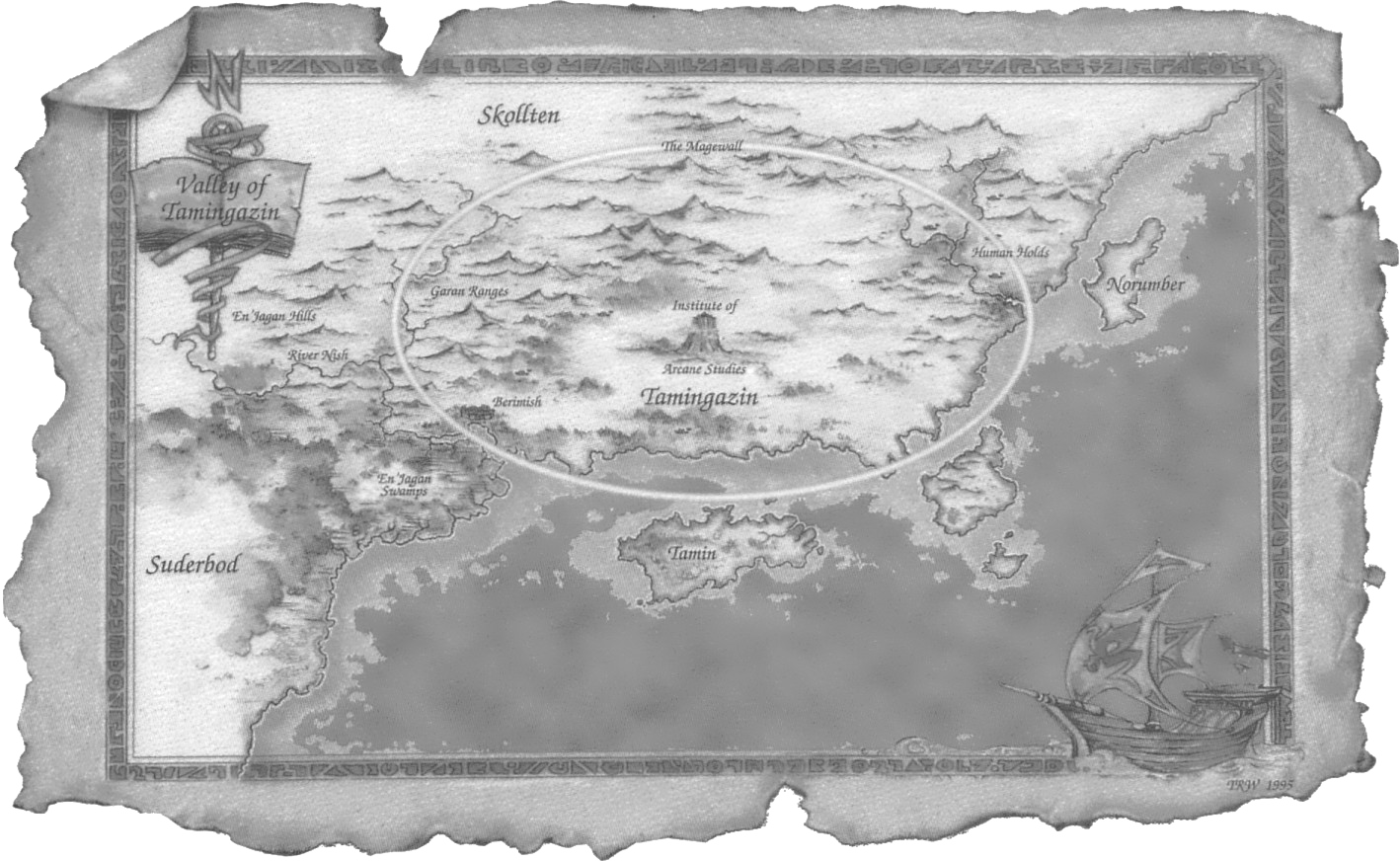
Maybe I could transplant the action of The Prodigal Sorcerer to another continent? Eastern Jamuraa wasn't being used for anything, right? I read the novel carefully, trying to find a place where I could put everything and have it make sense. (Months later, we found some of Pete's old notes and discovered that he had made a similar attempt!) It didn't work. It was clear that The Prodigal Sorcerer took place in the northern hemisphere, on a tall, narrow continent that extended well down into the tropics.
I considered a different approach, the "have your cake and eat it too" solution. What if The Prodigal Sorcerer took place on the same continent as Odyssey, Chainer's Torment, Judgment, Onslaught, Legions, and Scourge? I read through the Odyssey and Onslaught block novels (as well as the many short stories set on Otaria) and drew a map that integrated everything as best I could. The geographical details weren't perfectly consistent, but I managed to make a map that agreed with most of the references I found. And, good news! No scenes took place in the specific locations where Tamingazin needed to be. There was no reason that the reclusive Institute of Arcane Studies could not have coexisted with Kamahl, Jeska, Akroma, and friends!
My theory was that The Prodigal Sorcerer was set some time before the founding of the Cabal. After the events of the novel, Suderbod's government collapsed, its leadership killed and its treasure expended in its disastrous failed invasion of Tamingazin. Into the power vacuum stepped the Cabal patriarch. Meanwhile, Thriss, Nantuko Primus, planted trees in the western reaches of Suderbod, spreading the Krosan Forest northward over the centuries.
The only real sticking point were the Viashino. These lizardfolk featured prominently in The Prodigal Sorcerer, but appeared nowhere on Odyssey or Onslaught block cards. However, they were rather reclusive in The Prodigal Sorcerer, mostly staying in Tamingazin, and Kamahl fought a "lizard man" in the arena in the Odyssey novel, so I figured it was fine. There are Viashino living in Otaria, they just didn't appear on cards from Odyssey or Onslaught blocks.
Finishing the Map
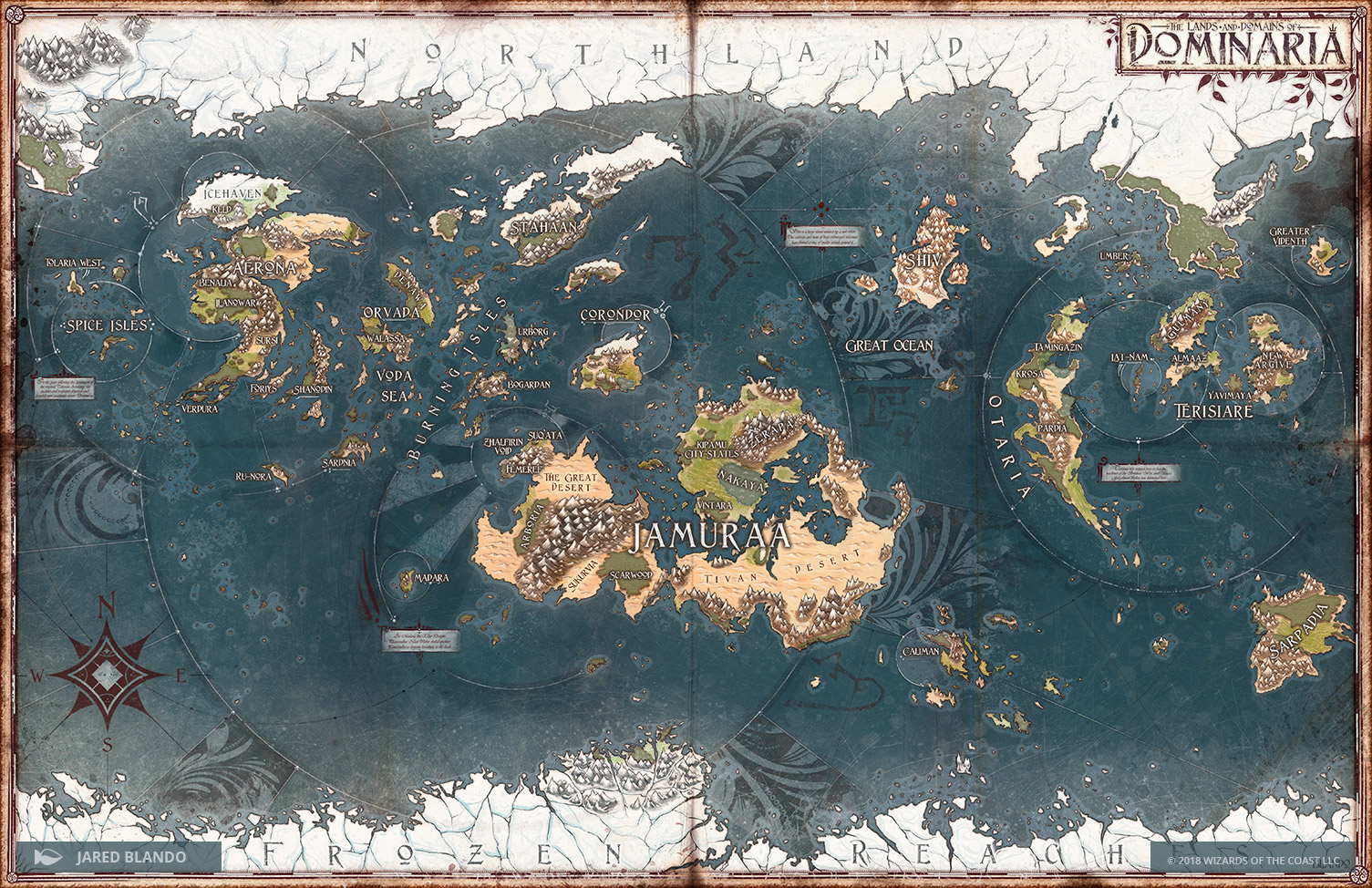
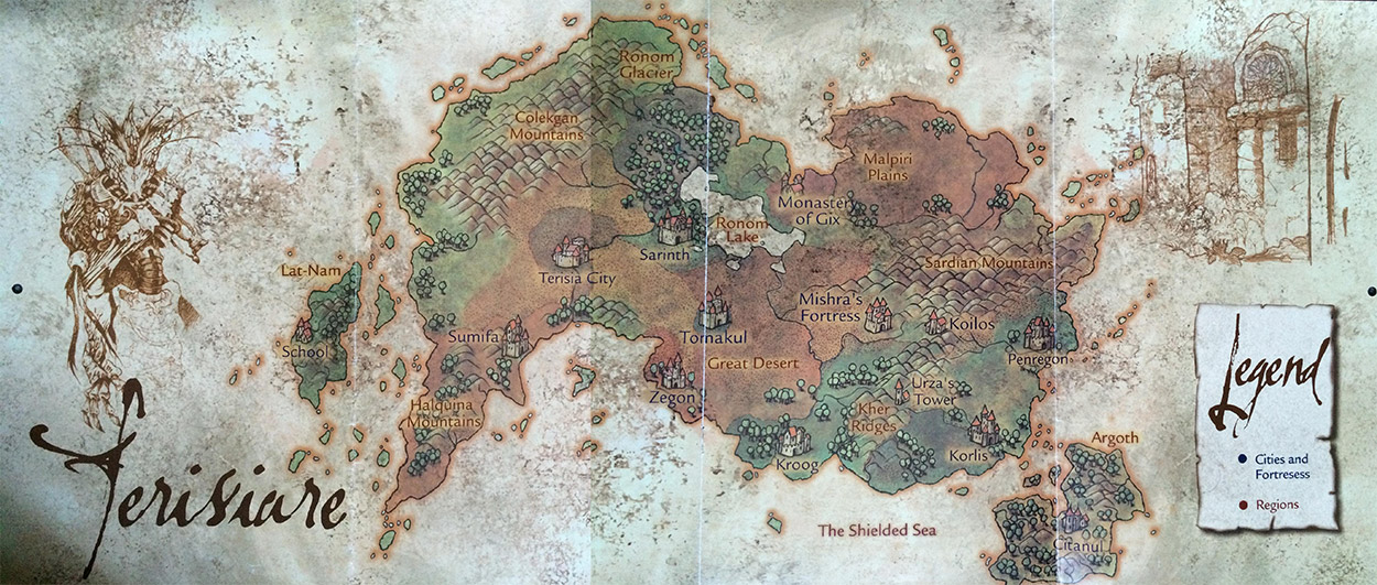
There were many other choices made about where this forest lay in relation to that mountain, but I managed to fill in every inch of the map by the deadline. Mark Winters worked with Jared Blando, an artist known for his beautiful fantasy maps, including the map of Ixalan. Jared did a stellar job turning my ugly-but-functional preliminary map into a feast for the eyes. We went through some rounds of revisions ("That's not how you spell Jamuraa," "You forgot to draw the Dueling Chasm of Corondor," "Can we replace this lorem ipsum text with real text? I'm sure Kelly won't mind writing something!")
The map was finished in time for the world guide, and really helped to communicate just how big Dominaria is, and where places are in relation to each other.
I . . . couldn't stop doing research. I kept reading books that covered lower-priority geographical topics, and of course I discovered a problem or two. We had labeled a huge forested region "Efrava," the home of Jedit Ojanen and his alternate-reality counterpart Jedit Ojanen of Efrava. My reading indicated that Efrava was a very small forest, nothing like what our map indicated. Further research indicated that it didn't even exist anymore!
My reading indicated that the region was actually supposed to be called "Scarwood" or "The Dark Heart of the Wood." I convinced Mark Winters that we should revise the map to be as accurate as possible. Changing text was pretty easy, so we fixed it.
"Mark," I said, "Doesn't Jamuraa look pretty empty to you?" We added "The Great Desert," "Arboria," "Sukurvia," and the "Kipamu City-States" so it wasn't so barren. We also added "Denawa" over in the Orvadan Empire, as we'd named that island for the Heroes of Dominaria board game, using a throwaway reference from the Rath and Storm novel.
Details and Specifications
A few details for cartography nerds (or aspiring cartography nerds) who want to deep dive into this subject:
- The map is a Mercator projection, so there's no scale listed. The farther you go from the equator, the more miles each inch equals.
- I believe that the latitudes farthest from the equator on the map are 72 degrees, but it's been a long time since I worked on it, so I may be misremembering. There weren't any geographical features of note farther north or south than 72 degrees that I'm aware of.
- The decorative border was laid over the map, so there's a tiny bit of information lost along the seam on the eastern and western borders of the map. Obviously there's nothing important there, but if one is to get an accurate measurement, one must have all of the facts!
I could go on and on about all of the details I incorporated into the map (and all of the details I left out!) but I think I covered all of the important stuff. It was a genuine pleasure to help bring the map to the fans, and do a little bit to better define the sprawling, glorious mess that is Dominaria!